Historic Truckee River Bike Path Ride Details
Challenge:
A level bike ride. Caution needed with the presence of many users: pedestrians, baby strollers, joggers, pets on leashes, river rafters, and fisherman.
Trailhead:
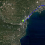
Starting your ride at the parking area, next to the Transit Center, cross the bike/ped bridge to connect to the bike path and turn left.
GPS: 39.164629, -120.147293 (Tahoe City Transit Center)
GPS: 39.204733, -120.199446 (Squaw Valley entrance)
The Bike Ride:
Historic Truckee River Bike Path: This is a great ride for the entire family – its level, relaxing and beautiful. You cruise alongside the Truckee River to the entrance of Squaw Valley. Along the way are several places to turn out to absorb the natural beauty of the river’s eco-system. During the summer months, the river is most popular for rafting and you can literally see hundreds of people enjoying a fun-filled flow down to River Ranch Resort – where they exit and is a great local spot for food, refreshments, and entertainment
Preview Ride:
Historical:
You are riding along the original Tahoe-Truckee Toll Road built in 1860 to enable horse-drawn freight and passenger wagons to travel between the Lake and Truckee. The river was used to float logs downstream to the mills in Truckee, and during the winter months the frozen river became a natural supplier of much needed ice for the mining operations in Virginia City. Later in the 1880’s, this route became the corridor for a narrow gauge railroad hauling logs to the Truckee mills, and then in the early 1900’s automobiles traveled on what was then called the Truckee Turnpike. This was an important transportation route for commerce, freight, and tourists traveling from Tahoe to Truckee and beyond to Sacramento, San Francisco, and Reno.