Squaw Valley Bike Path Cruiser Ride Details
Challenge:
A level and leisure cruise.
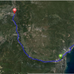
Trailhead:
By Bike: At the end of the Historic Truckee River Cruise cross Hwy 89 to continue your ride.
By Car: Located at the junction of Hwy 89 and Squaw Valley Rd.
GPS: 39.204733, -120.199446 (Squaw Valley entrance)
The Bike Ride:
Squaw Valley Bike Path: Squaw Valley is one of the most beautiful alpine valleys in the region. As you ride along the bike path and enter the valley your eyes are initially drawn forward looking at a natural amphitheater with a lush meadow in the foreground surrounded by majestic peaks. Your mind can quickly imagine what it must have been like to camp in the meadow prior to development.
Historical:
Early, Squaw Valley was a summer tribal ground for the Washoe tribe who encamped there while the men would go out to gather grasshoppers and hunt for animals. It’s believed the name came from the emigrants who noticed mostly squaws (female Indians) were in the camp. Later in the mid 1800’s, emigrants seeking a shorter and easier route to Sacramento built “Squaw Valley Trail” over the Sierras there. But, with popular competition of the Echo and Donner Summit passages the Squaw route was abandoned. In the late 1800’s, emigrants settled here and farmed for hay, grew vegetables, berries and produced butter and cheese for the local population. In 1949, the Squaw Valley Development Company took control of the valley which lead to land development, the building of a world-class ski resort, and the subsequent site of the 1960 Winter Olympic Games.