Incline Flume Ride Details
Challenge:
A steady undulating single track with little elevation gain.
Trailhead:
Lat: 39.2673242, -119.9309856
Located just off My Rose Hwy 431 approximately 500 yards, eastbound, from the Scenic Overlook. Large parking area on the left of hwy. Park there and cautiously cross the highway to the trailhead.
The Ride:
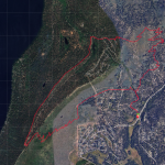
This is a fun short single-track ride for the family with classic Lake Tahoe views. The ride is a traverse across the Carson Mountain Range, beginning at Mount Rose Highway, crossing upper Diamond Peak Ski Resort trails, and connecting to Tunnel Creek Road.
Ride Options
Out & Back: Some riders enjoy an out and back from Mt Rose Hwy to Tunnel Creek Road and back-12.32 mi.
Marlette Flume: At Tunnel Creek Road junction, turn left and climb to Marlette Flume Trail junction:
39.218607, -119.909669. Here, you can ride to Marlette Lake.