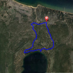
Corral Loop Mountain Bike Trail Details
Challenge:
It is a steep climb from the parking area along paved Fountain Place road. Riding on the single track are rocky sections, free-ride features (table tops, berms, tree rides), and sandy areas on the downhill.
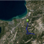
Trailhead:
Travel along Pioneer TR and turn left of Oneidas Rd. and pass the forest service gate where the paved road continues as Fountain Place. Just passing the creek bridge is the parking area and launch zone. Ride up Fountain Place Rd. 2 miles to the trailhead located on the left, just past a cattle grate and widened parking area where you will see a mapped kiosk.
GPS: 38.866844, -119.956253 (Corral TH)
GPS: 38.866844, -119.956252 (Parking area)
GPS: 38.8649, -119.997786 (Oneidas Rd.)
The Ride:
Corral Loop mountain bike trail has been transformed the last couple of years through the collaborative efforts of the US Forest Service and Tahoe Area Mountain Biking Association (TAMBA), a local bicycle advocate trail organization. Together they have built features that include table top jumps, log rides, and berms for a freeriding style of riding. This is the most popular ride for downhill and freeride riders because of the features. Rider speeds can be fast. It connects with Powerline Road, a double track road where you turn left and return to the parking area .85 miles.
Preview the Ride: